
Carte topographique Saint Joseph County
Carte interactive
Cliquez sur la carte pour afficher l’altitude.
À propos de cette carte
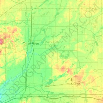
Nom : Carte topographique Saint Joseph County, altitude, relief.
Lieu : Saint Joseph County, Michigan, United States of America (41.75905 -85.79185 42.07161 -85.29214)
Altitude moyenne : 262 m
Altitude minimum : 228 m
Altitude maximum : 346 m
Autres cartes topographiques
Cliquez sur une carte pour visualiser sa topographie, son altitude et son relief.
Leelanau County
United States of America > Michigan
Leelanau County, Michigan, United States of America
Altitude moyenne : 185 m
Bay City
United States of America > Michigan > Bay City
Bay City, Bay County, Michigan, 48708, United States of America
Altitude moyenne : 182 m
Ingham County
United States of America > Michigan
Ingham County, Michigan, United States of America
Altitude moyenne : 278 m
Shiawassee County
United States of America > Michigan
Shiawassee County, Michigan, United States of America
Altitude moyenne : 241 m
Ludington
United States of America > Michigan > Ludington
Ludington, Mason County, Michigan, United States of America
Altitude moyenne : 184 m
Ontonagon County
United States of America > Michigan
Ontonagon County, Michigan, United States of America
Altitude moyenne : 334 m
Lake Saint Clair
United States of America > Michigan > Waldenburg
Lake Saint Clair, Hall Road, Waldenburg, Macomb Township, Macomb County, Michigan, 48044, United States of America
Altitude moyenne : 177 m
Grand Traverse County
United States of America > Michigan
Grand Traverse County, Michigan, United States of America
Altitude moyenne : 246 m
Baraga County
United States of America > Michigan
Baraga County, Michigan, United States of America
Altitude moyenne : 378 m
East Lansing
United States of America > Michigan > East Lansing
East Lansing, Ingham County, Michigan, United States of America
Altitude moyenne : 261 m