
Carte topographique Aylesford
Carte interactive
Cliquez sur la carte pour afficher l’altitude.
À propos de cette carte
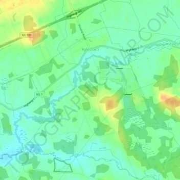
Nom : Carte topographique Aylesford, altitude, relief.
Altitude moyenne : 30 m
Altitude minimum : 18 m
Altitude maximum : 50 m
Autres cartes topographiques
Cliquez sur une carte pour visualiser sa topographie, son altitude et son relief.
Annapolis Valley
Canada > Nova Scotia > Municipality of the County of Kings > Auburn
Annapolis Valley, Auburn, Municipality of the County of Kings, Kings County, Nova Scotia, B0P 1R0, Canada
Altitude moyenne : 77 m
Lake Paul
Canada > Nova Scotia > Municipality of the County of Kings
Lake Paul, Municipality of the County of Kings, Kings County, Nova Scotia, B0P 1C0, Canada
Altitude moyenne : 222 m
Grand Pre
Canada > Nova Scotia > Municipality of the County of Kings
Grand Pre, Municipality of the County of Kings, Kings County, Nova Scotia, B0P 1M0, Canada
Altitude moyenne : 21 m
Coldbrook
Canada > Nova Scotia > Municipality of the County of Kings
Coldbrook, Municipality of the County of Kings, Kings County, Nova Scotia, Canada
Altitude moyenne : 79 m
Berwick West
Canada > Nova Scotia > Municipality of the County of Kings
Berwick West, Municipality of the County of Kings, Kings County, Nova Scotia, Canada
Altitude moyenne : 38 m
Armstrong Lake
Canada > Nova Scotia > Municipality of the County of Kings
Armstrong Lake, Municipality of the County of Kings, Kings County, Nova Scotia, Canada
Altitude moyenne : 208 m
Upper Dyke
Canada > Nova Scotia > Municipality of the County of Kings
Upper Dyke, Municipality of the County of Kings, Kings County, Nova Scotia, Canada
Altitude moyenne : 18 m
Upper Canard
Canada > Nova Scotia > Municipality of the County of Kings
Upper Canard, Municipality of the County of Kings, Kings County, Nova Scotia, Canada
Altitude moyenne : 13 m
Brow of the Mountain
Canada > Nova Scotia > Municipality of the County of Kings
Brow of the Mountain, Municipality of the County of Kings, Kings County, Nova Scotia, Canada
Altitude moyenne : 136 m
Frog Lake
Canada > Nova Scotia > Municipality of the County of Kings
Frog Lake, Municipality of the County of Kings, Kings County, Nova Scotia, Canada
Altitude moyenne : 211 m
Black River Lake
Canada > Nova Scotia > Municipality of the County of Kings
Black River Lake, Municipality of the County of Kings, Kings County, Nova Scotia, Canada
Altitude moyenne : 188 m
Hardwood Lake
Canada > Nova Scotia > Municipality of the County of Kings
Hardwood Lake, Municipality of the County of Kings, Kings County, Nova Scotia, Canada
Altitude moyenne : 218 m
Tremont
Canada > Nova Scotia > Municipality of the County of Kings
Tremont, Municipality of the County of Kings, Kings County, Nova Scotia, B0P 1R0, Canada
Altitude moyenne : 58 m
Welsford
Canada > Nova Scotia > Municipality of the County of Kings
Welsford, Municipality of the County of Kings, Kings County, Nova Scotia, B0P 1E0, Canada
Altitude moyenne : 129 m
Newtonville
Canada > Nova Scotia > Municipality of the County of Kings
Newtonville, Municipality of the County of Kings, Kings County, Nova Scotia, B4P 2R1, Canada
Altitude moyenne : 158 m
North Kentville
Canada > Nova Scotia > Municipality of the County of Kings
North Kentville, Municipality of the County of Kings, Kings County, Nova Scotia, Canada
Altitude moyenne : 29 m
Cape Split
Canada > Nova Scotia > Municipality of the County of Kings > Scots Bay
Cape Split, Scots Bay, Municipality of the County of Kings, Kings County, Nova Scotia, Canada
Altitude moyenne : 6 m
Morristown
Canada > Nova Scotia > Municipality of the County of Kings
Morristown, Municipality of the County of Kings, Kings County, Nova Scotia, B0P 1E0, Canada
Altitude moyenne : 167 m
Harbourville
Canada > Nova Scotia > Municipality of the County of Kings
Harbourville, Municipality of the County of Kings, Kings County, Nova Scotia, Canada
Altitude moyenne : 86 m
Tomahawk Lake
Canada > Nova Scotia > Municipality of the County of Kings
Tomahawk Lake, Municipality of the County of Kings, Kings County, Nova Scotia, Canada
Altitude moyenne : 222 m
Gaspereau Mountain
Canada > Nova Scotia > Municipality of the County of Kings > Forest Hill
Gaspereau Mountain, Forest Hill, Municipality of the County of Kings, Kings County, Nova Scotia, B4P 2R1, Canada
Altitude moyenne : 185 m
Dalhousie Road
Canada > Nova Scotia > Municipality of the County of Kings
Dalhousie Road, East Dalhousie, Municipality of the County of Kings, Kings County, Nova Scotia, B0R 1H0, Canada
Altitude moyenne : 207 m
Blue Mountain
Canada > Nova Scotia > Municipality of the County of Kings
Blue Mountain, Municipality of the County of Kings, Kings County, Nova Scotia, B4N 3V8, Canada
Altitude moyenne : 224 m
Murphy Lake
Canada > Nova Scotia > Municipality of the County of Kings
Murphy Lake, Municipality of the County of Kings, Kings County, Nova Scotia, B4N 3V8, Canada
Altitude moyenne : 211 m
Greenwood
Canada > Nova Scotia > Municipality of the County of Kings
Greenwood, Municipality of the County of Kings, Kings County, Nova Scotia, B0P 1N0, Canada
Altitude moyenne : 28 m
Greenwich
Canada > Nova Scotia > Municipality of the County of Kings
Greenwich, Municipality of the County of Kings, Kings County, Nova Scotia, B4P 0B2, Canada
Altitude moyenne : 32 m
Canning
Canada > Nova Scotia > Municipality of the County of Kings
Canning, Municipality of the County of Kings, Kings County, Nova Scotia, B0P 1H0, Canada
Altitude moyenne : 22 m
Black River
Canada > Nova Scotia > Municipality of the County of Kings > Black River
Black River, Municipality of the County of Kings, Kings County, Nova Scotia, Canada
Altitude moyenne : 195 m
New Minas
Canada > Nova Scotia > Municipality of the County of Kings
New Minas, Municipality of the County of Kings, Kings County, Nova Scotia, Canada
Altitude moyenne : 63 m
Lumsden Dam
Canada > Nova Scotia > Municipality of the County of Kings
Lumsden Dam, Municipality of the County of Kings, Kings County, Nova Scotia, Canada
Altitude moyenne : 182 m
Blomidon
Canada > Nova Scotia > Municipality of the County of Kings
Blomidon, Municipality of the County of Kings, Kings County, Nova Scotia, B0P 1T0, Canada
Altitude moyenne : 56 m
Avonport
Canada > Nova Scotia > Municipality of the County of Kings
Avonport, Municipality of the County of Kings, Kings County, Nova Scotia, B0P 1B0, Canada
Altitude moyenne : 26 m
Gaspereau
Canada > Nova Scotia > Municipality of the County of Kings > Gaspereau
Gaspereau, Municipality of the County of Kings, Kings County, Nova Scotia, B4P 2R1, Canada
Altitude moyenne : 95 m
Hants Border
Canada > Nova Scotia > Municipality of the County of Kings
Hants Border, Municipality of the County of Kings, Kings County, Nova Scotia, B0P 1P0, Canada
Altitude moyenne : 58 m
Davison Street
Canada > Nova Scotia > Municipality of the County of Kings > Forest Hill
Davison Street, Forest Hill, Municipality of the County of Kings, Kings County, Nova Scotia, B4P 2R1, Canada
Altitude moyenne : 195 m