
Carte topographique Lake Arlington
Carte interactive
Cliquez sur la carte pour afficher l’altitude.
À propos de cette carte
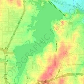
Nom : Carte topographique Lake Arlington, altitude, relief.
Altitude moyenne : 179 m
Altitude minimum : 148 m
Altitude maximum : 214 m
Autres cartes topographiques
Cliquez sur une carte pour visualiser sa topographie, son altitude et son relief.
Johnson creek
United States > Texas > Tarrant County > Arlington
Johnson creek, Arlington, Tarrant County, Texas, 76015, United States
Altitude moyenne : 198 m
La Frontera
United States > Texas > Tarrant County > Arlington > La Frontera
La Frontera, Arlington, Tarrant County, Texas, 76002, United States
Altitude moyenne : 185 m