
Carte topographique Bunchrew
Carte interactive
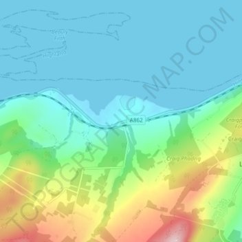
Cliquez sur la carte pour afficher l’altitude.
À propos de cette carte
Nom : Carte topographique Bunchrew, altitude, relief.
Altitude moyenne : 66 m
Altitude minimum : 0 m
Altitude maximum : 281 m
Autres cartes topographiques
Cliquez sur une carte pour visualiser sa topographie, son altitude et son relief.
Scaniport
United Kingdom > Scotland > Highland > Inverness
Scaniport, Inverness, Highland, Scotland, IV2 6DL, United Kingdom
Altitude moyenne : 85 m