
Carte topographique Legazpi
Carte interactive
Cliquez sur la carte pour afficher l’altitude.
À propos de cette carte
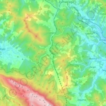
Nom : Carte topographique Legazpi, altitude, relief.
Altitude moyenne : 548 m
Altitude minimum : 195 m
Altitude maximum : 1 411 m
Autres cartes topographiques
Cliquez sur une carte pour visualiser sa topographie, son altitude et son relief.
Soil
Spain > Autonomous Community of the Basque Country > Montaña Alavesa/Arabako Mendialdea
Soil, Arraia-Maeztu, Montaña Alavesa/Arabako Mendialdea, Álava, Autonomous Community of the Basque Country, 01207, Spain
Altitude moyenne : 898 m
San Sebastián
Spain > Autonomous Community of the Basque Country
San Sebastián, Gipuzkoa, Autonomous Community of the Basque Country, Spain
Altitude moyenne : 120 m
Orio
Spain > Autonomous Community of the Basque Country > Urola-Kosta
Orio, Urola-Kosta, Gipuzkoa, Autonomous Community of the Basque Country, 20810, Spain
Altitude moyenne : 50 m
Gaintza
Spain > Autonomous Community of the Basque Country
Gaintza, Gipuzkoa, Autonomous Community of the Basque Country, Spain
Altitude moyenne : 327 m
Donostia / San Sebastián
Spain > Autonomous Community of the Basque Country > Donostialdea > Donostia / San Sebastián
Donostia / San Sebastián, San Sebastián, Donostialdea, Gipuzkoa, Autonomous Community of the Basque Country, 20003, Spain
Altitude moyenne : 134 m
Bilbao
Spain > Autonomous Community of the Basque Country > Bilbao
Bilbao, Biscay, Autonomous Community of the Basque Country, Spain
Altitude moyenne : 156 m