
Carte topographique Thanh Phu District
Carte interactive
Cliquez sur la carte pour afficher l’altitude.
À propos de cette carte
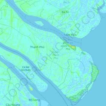
Nom : Carte topographique Thanh Phu District, altitude, relief.
Lieu : Thanh Phu District, Bến Tre Province, Vietnam (9.79398 106.39977 10.07064 106.68694)
Altitude moyenne : 1 m
Altitude minimum : -3 m
Altitude maximum : 12 m
Autres cartes topographiques
Cliquez sur une carte pour visualiser sa topographie, son altitude et son relief.
Xã Bình Khánh
Vietnam > Bến Tre Province > Mỏ Cày Nam District
Xã Bình Khánh, Mỏ Cày Nam District, Bến Tre Province, Vietnam
Altitude moyenne : 3 m
Xã Bình Thạnh
Vietnam > Bến Tre Province > Thanh Phu District
Xã Bình Thạnh, Thanh Phu District, Bến Tre Province, Vietnam
Altitude moyenne : 1 m
Chau Thanh
Vietnam > Bến Tre Province > Chau Thanh District
Chau Thanh, Chau Thanh District, Bến Tre Province, 86000, Vietnam
Altitude moyenne : 3 m
Long Thành
Vietnam > Bến Tre Province > Giồng Trôm District
Long Thành, Giồng Trôm District, Bến Tre Province, Vietnam
Altitude moyenne : 3 m
Tân Tây
Vietnam > Bến Tre Province > Chau Thanh District
Tân Tây, Chau Thanh District, Bến Tre Province, 86309, Vietnam
Altitude moyenne : 2 m
Tanh Phú Đông
Vietnam > Bến Tre Province > Tanh Phú Đông
Tanh Phú Đông, Giồng Trôm District, Bến Tre Province, Vietnam
Altitude moyenne : 3 m