
Faire un don
Équipez-vous pour votre prochaine aventure :
En tant que Partenaire Amazon, ce site perçoit une commission sur les achats éligibles sans surcoût pour vous.
Carte topographique Handwara
Cliquez sur la carte pour afficher l’altitude.
Faire un don
Équipez-vous pour votre prochaine aventure :
En tant que Partenaire Amazon, ce site perçoit une commission sur les achats éligibles sans surcoût pour vous.
Handwara
Handwara is located at 34°24′N 74°17′E / 34.40°N 74.28°E / 34.40; 74.28 at an average elevation of 1,582 metres (5,190 feet) above sea level. The region boasts breathtaking natural beauty, with the Pohru River (locally called 'Talri river')—a tributary of the Jhelum—flowing through the town.
Faire un don
Équipez-vous pour votre prochaine aventure :
En tant que Partenaire Amazon, ce site perçoit une commission sur les achats éligibles sans surcoût pour vous.
À propos de cette carte
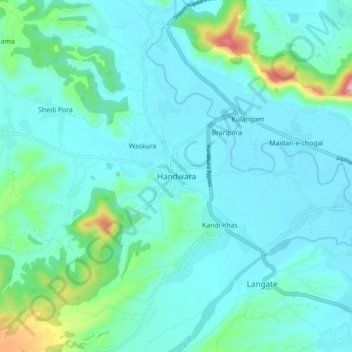
Nom : Carte topographique Handwara, altitude, relief.
Altitude moyenne : 1 638 m
Altitude minimum : 1 586 m
Altitude maximum : 1 931 m
Faire un don
Équipez-vous pour votre prochaine aventure :
En tant que Partenaire Amazon, ce site perçoit une commission sur les achats éligibles sans surcoût pour vous.