
Carte topographique Up Holland
Carte interactive
Cliquez sur la carte pour afficher l’altitude.
À propos de cette carte
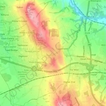
Nom : Carte topographique Up Holland, altitude, relief.
Altitude moyenne : 89 m
Altitude minimum : 16 m
Altitude maximum : 179 m
Autres cartes topographiques
Cliquez sur une carte pour visualiser sa topographie, son altitude et son relief.
Tontine
United Kingdom > England > Lancashire > West Lancashire > Upholland > Tontine
Tontine, Up Holland, Upholland, West Lancashire, Lancashire, North West England, England, WN5 8UJ, United Kingdom
Altitude moyenne : 101 m