
Faire un don
Équipez-vous pour votre prochaine aventure :
En tant que Partenaire Amazon, ce site perçoit une commission sur les achats éligibles sans surcoût pour vous.
Carte topographique Englewood
Cliquez sur la carte pour afficher l’altitude.
Faire un don
Équipez-vous pour votre prochaine aventure :
En tant que Partenaire Amazon, ce site perçoit une commission sur les achats éligibles sans surcoût pour vous.
Englewood
Englewood features a diverse topography characterized by flat coastal plains and gently rolling terrain. The area is predominantly low-lying, with elevations rarely exceeding 20 feet above sea level, making it susceptible to tidal influences from the Gulf of Mexico. The landscape is interspersed with wetlands, estuaries, and salt marshes, particularly around Lemon Bay, which provide rich habitats for wildlife. Along the coastline, sandy beaches stretch for miles, offering a scenic backdrop against the turquoise waters. Inland, the terrain transitions into residential neighborhoods and parks, with sporadic pockets of vegetation, including pine and palm trees, contributing to the region's natural beauty.
Faire un don
Équipez-vous pour votre prochaine aventure :
En tant que Partenaire Amazon, ce site perçoit une commission sur les achats éligibles sans surcoût pour vous.
À propos de cette carte
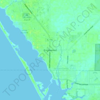
Nom : Carte topographique Englewood, altitude, relief.
Lieu : Englewood, Sarasota County, Florida, FL 34223, USA (26.92201 -82.39260 27.00201 -82.31260)
Altitude moyenne : 3 m
Altitude minimum : -1 m
Altitude maximum : 11 m
Faire un don
Équipez-vous pour votre prochaine aventure :
En tant que Partenaire Amazon, ce site perçoit une commission sur les achats éligibles sans surcoût pour vous.