
Carte topographique Vung Tau City
Carte interactive
Cliquez sur la carte pour afficher l’altitude.
À propos de cette carte
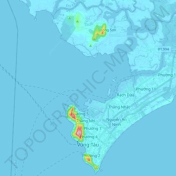
Nom : Carte topographique Vung Tau City, altitude, relief.
Lieu : Vung Tau City, Bà Rịa - Vũng Tàu Province, Vietnam (10.32030 107.04181 10.48418 107.21176)
Altitude moyenne : 3 m
Altitude minimum : -9 m
Altitude maximum : 245 m
Autres cartes topographiques
Cliquez sur une carte pour visualiser sa topographie, son altitude et son relief.
Hồ Đá Bàng
Vietnam > Bà Rịa - Vũng Tàu Province > Chau Duc District > Da Bac Commune
Hồ Đá Bàng, Da Bac Commune, Chau Duc District, Bà Rịa - Vũng Tàu Province, Vietnam
Altitude moyenne : 45 m
Côn Sơn Island
Vietnam > Bà Rịa - Vũng Tàu Province > Con Dao
Côn Sơn Island, Con Dao, Côn Đảo District, Bà Rịa - Vũng Tàu Province, Vietnam
Altitude moyenne : 2 m
Green Island
Vietnam > Bà Rịa - Vũng Tàu Province
Green Island, Bà Rịa - Vũng Tàu Province, Vietnam
Altitude moyenne : 1 m