
Carte topographique East Palestine
Carte interactive
Cliquez sur la carte pour afficher l’altitude.
À propos de cette carte
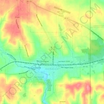
Nom : Carte topographique East Palestine, altitude, relief.
Altitude moyenne : 341 m
Altitude minimum : 295 m
Altitude maximum : 383 m
Autres cartes topographiques
Cliquez sur une carte pour visualiser sa topographie, son altitude et son relief.
Valley
United States > Ohio > Columbiana County
Valley, Columbiana County, Ohio, 44619, United States
Altitude moyenne : 376 m
North Georgetown
United States > Ohio > Columbiana County
North Georgetown, Columbiana County, Ohio, 44665, United States
Altitude moyenne : 357 m
Salem
United States > Ohio > Columbiana County > Salem
Salem, Columbiana County, Ohio, 44460, United States
Altitude moyenne : 375 m