
Carte topographique Quỳnh Nhai District
Carte interactive
Cliquez sur la carte pour afficher l’altitude.
À propos de cette carte
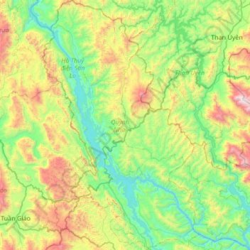
Nom : Carte topographique Quỳnh Nhai District, altitude, relief.
Lieu : Quỳnh Nhai District, Sơn La Province, Vietnam (21.52376 103.47992 22.03070 103.82203)
Altitude moyenne : 707 m
Altitude minimum : 117 m
Altitude maximum : 2 203 m
Autres cartes topographiques
Cliquez sur une carte pour visualiser sa topographie, son altitude et son relief.
Moc Chau
Vietnam > Son La province > Mộc Châu District
Moc Chau, Mộc Châu District, Sơn La Province, 34719, Vietnam
Altitude moyenne : 916 m
Chieng khoa watefall
Vietnam > Son La province > Vân Hồ District > Mường Khoa
Chieng khoa watefall, Mường Khoa, Vân Hồ District, Sơn La Province, Vietnam
Altitude moyenne : 388 m
Mường La District
Mường La District, Son La province, Vietnam
Altitude moyenne : 1 057 m
Black River
Black River, Mường La District, Son La province, 02103, Vietnam
Altitude moyenne : 786 m