
Carte topographique Madulain
Carte interactive
Cliquez sur la carte pour afficher l’altitude.
À propos de cette carte
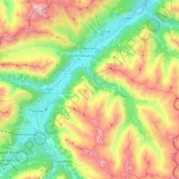
Nom : Carte topographique Madulain, altitude, relief.
Lieu : Madulain, Maloja, Grisons, 7523, Switzerland (46.47497 9.89879 46.62785 10.02502)
Altitude moyenne : 2 330 m
Altitude minimum : 1 627 m
Altitude maximum : 3 393 m
Before 2017, the municipality was located in the Oberengadin sub-district of the Maloja district, after 2017 it was part of the Maloja Region. It is the smallest of the eleven municipalities in the district. It is located in the upper Engadin valley between La Punt Chamues-ch and Zuoz about 15 minutes from St. Moritz on the Inn River. It consists of the Haufendorf village (an irregular, unplanned and quite closely packed village, built around a central square) of Madulain on the Inn at an elevation of 1,684 m (5,525 ft). Until 1943 Madulain was known as Madulein.
Autres cartes topographiques
Cliquez sur une carte pour visualiser sa topographie, son altitude et son relief.
Sankt Moritz
Switzerland > Grisons > Maloja
Sankt Moritz, Maloja, Grisons, 7500, Switzerland
Altitude moyenne : 2 174 m