
Carte topographique Sondu
Carte interactive
Cliquez sur la carte pour afficher l’altitude.
À propos de cette carte
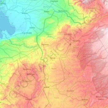
Nom : Carte topographique Sondu, altitude, relief.
Lieu : Sondu, Kericho County, Rift Valley, Kenya (-0.60871 34.76291 -0.31234 35.52284)
Altitude moyenne : 1 760 m
Altitude minimum : 1 132 m
Altitude maximum : 2 585 m
Autres cartes topographiques
Cliquez sur une carte pour visualiser sa topographie, son altitude et son relief.
Sigowet
Kenya > Kericho County > Sigowet/Soin
Sigowet, Sigowet/Soin, Kericho County, Kenya
Altitude moyenne : 1 713 m
Kipkelion
Kenya > Kericho County > Kipkelion
Kipkelion, Kericho County, Kenya
Altitude moyenne : 2 013 m
Kericho
Kenya > Kericho County > Ainamoi
Kericho, Ainamoi, Kericho County, Rift Valley, Kenya
Altitude moyenne : 1 988 m