
Carte topographique Wiesbaden
Carte interactive
Cliquez sur la carte pour afficher l’altitude.
À propos de cette carte
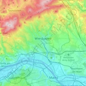
Nom : Carte topographique Wiesbaden, altitude, relief.
Lieu : Wiesbaden, Hesse, Germany (49.99328 8.11067 50.15181 8.38616)
Altitude moyenne : 221 m
Altitude minimum : 79 m
Altitude maximum : 621 m
The highest point of the Wiesbaden municipality is located northwest of the city center near the summit of the Hohe Wurzel, with an elevation of 608 metres (1,995 ft) above sea level. The lowest point is the harbour entrance of Schierstein at 83 metres (272 ft) above sea level. The central square (the Schlossplatz, or palace square) is at an elevation of 115 metres (377 ft).
Autres cartes topographiques
Cliquez sur une carte pour visualiser sa topographie, son altitude et son relief.
Bischofsheim
Germany > Hesse > Bischofsheim
Bischofsheim, Kreis Groß-Gerau, Hesse, Germany
Altitude moyenne : 91 m
Offenbach am Main
Germany > Hesse > Offenbach am Main
Offenbach am Main, Hesse, 63065, Germany
Altitude moyenne : 118 m
Nied
Germany > Hesse > Frankfurt am Main
Nied, Frankfurt am Main, Regierungsbezirk Darmstadt, Hesse, 65934, Germany
Altitude moyenne : 98 m
Hüttenberg
Germany > Hesse > Hüttenberg
Hüttenberg, Lahn-Dill-Kreis, Regierungsbezirk Gießen, Hesse, 35625, Germany
Altitude moyenne : 230 m