
Carte topographique Glencoe
Carte interactive
Cliquez sur la carte pour afficher l’altitude.
À propos de cette carte
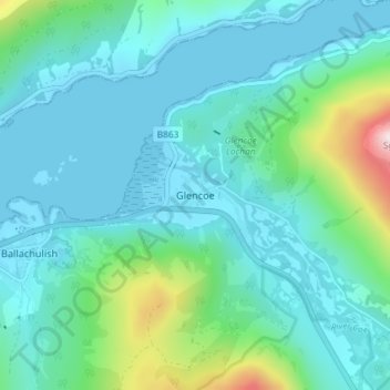
Nom : Carte topographique Glencoe, altitude, relief.
Lieu : Glencoe, Highland, Schotland, PH49 4HS, Verenigd Koninkrijk (56.66276 -5.12146 56.70276 -5.08146)
Altitude moyenne : 114 m
Altitude minimum : -1 m
Altitude maximum : 682 m
Autres cartes topographiques
Cliquez sur une carte pour visualiser sa topographie, son altitude et son relief.
Fort William
Verenigd Koninkrijk > Schotland > Highland
Fort William, Highland, Schotland, PH33 6AQ, Verenigd Koninkrijk
Altitude moyenne : 122 m
Loch Teth
Verenigd Koninkrijk > Schotland > Highland
Loch Teth, Highland, Schotland, Verenigd Koninkrijk
Altitude moyenne : 94 m
Glen Coe
Verenigd Koninkrijk > Schotland > Highland > Glencoe
Glen Coe, Glencoe, Highland, Schotland, Verenigd Koninkrijk
Altitude moyenne : 414 m
Glen Etive
Verenigd Koninkrijk > Schotland > Highland
Glen Etive, Highland, Schotland, Verenigd Koninkrijk
Altitude moyenne : 477 m
Loch Bealach nam Buthan
Verenigd Koninkrijk > Schotland > Highland
Loch Bealach nam Buthan, Highland, Schotland, Verenigd Koninkrijk
Altitude moyenne : 586 m
River Etive
Verenigd Koninkrijk > Schotland > Highland
River Etive, Highland, Schotland, Verenigd Koninkrijk
Altitude moyenne : 331 m
Scottish Highlands
Verenigd Koninkrijk > Schotland > Highland
Scottish Highlands, Highland, Schotland, Verenigd Koninkrijk
Altitude moyenne : 907 m
Portree - Port Rìgh
Verenigd Koninkrijk > Schotland > Highland
Portree - Port Rìgh, Highland, Schotland, IV51 9EH, Verenigd Koninkrijk
Altitude moyenne : 121 m
Aviemore
Verenigd Koninkrijk > Schotland > Highland > Aviemore
Aviemore, Highland, Schotland, PH22 1RN, Verenigd Koninkrijk
Altitude moyenne : 331 m
Stein
Verenigd Koninkrijk > Schotland > Highland > Stein
Stein, Highland, Schotland, IV55 8GA, Verenigd Koninkrijk
Altitude moyenne : 98 m
Ben Nevis
Verenigd Koninkrijk > Schotland > Highland
Ben Nevis, Highland, Schotland, Verenigd Koninkrijk
Altitude moyenne : 912 m
Skye
Verenigd Koninkrijk > Schotland > Highland
Skye, Highland, Schotland, Verenigd Koninkrijk
Altitude moyenne : 63 m