
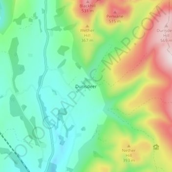
Carte topographique Durisdeer
Carte interactive
Cliquez sur la carte pour afficher l’altitude.
À propos de cette carte
Nom : Carte topographique Durisdeer, altitude, relief.
Altitude moyenne : 270 m
Altitude minimum : 112 m
Altitude maximum : 589 m
Autres cartes topographiques
Cliquez sur une carte pour visualiser sa topographie, son altitude et son relief.
Port Logan
United Kingdom > Scotland > Dumfries and Galloway
Port Logan, Dumfries and Galloway, Scotland, DG9 9NL, United Kingdom
Altitude moyenne : 30 m
Fingland
United Kingdom > Scotland > Dumfries and Galloway
Fingland, Dumfries and Galloway, Scotland, DG11 2LD, United Kingdom
Altitude moyenne : 206 m
Moniaive
United Kingdom > Scotland > Dumfries and Galloway
Moniaive, Dumfries and Galloway, Scotland, DG3 4HN, United Kingdom
Altitude moyenne : 179 m
Eskdalemuir
United Kingdom > Scotland > Dumfries and Galloway
Eskdalemuir, Dumfries and Galloway, Scotland, DG13 0QF, United Kingdom
Altitude moyenne : 246 m
Doons
United Kingdom > Scotland > Dumfries and Galloway
Doons, Dumfries and Galloway, Scotland, DG3 4NG, United Kingdom
Altitude moyenne : 202 m