
Carte topographique Corbriggs
Cliquez sur la carte pour afficher l’altitude.
À propos de cette carte
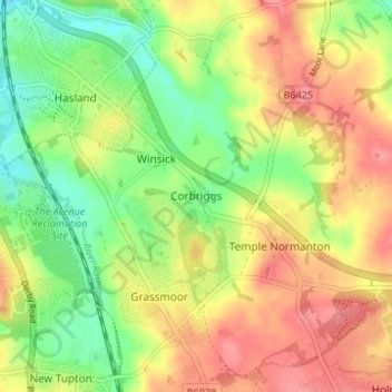
Nom : Carte topographique Corbriggs, altitude, relief.
Altitude moyenne : 114 m
Altitude minimum : 74 m
Altitude maximum : 152 m
Autres cartes topographiques
Cliquez sur une carte pour visualiser sa topographie, son altitude et son relief.
North Wingfield
United Kingdom > England > Derbyshire > North East Derbyshire
Altitude moyenne : 126 m
Ogston Reservoir
United Kingdom > England > Derbyshire > North East Derbyshire > Woolley Moor
Altitude moyenne : 137 m
Doghole Wood
United Kingdom > England > Derbyshire > North East Derbyshire > Holymoorside
Altitude moyenne : 142 m
Brackenfield CP
United Kingdom > England > Derbyshire > North East Derbyshire
Altitude moyenne : 168 m
Dronfield Nature Park
United Kingdom > England > Derbyshire > North East Derbyshire > Dronfield > Unstone Green
Altitude moyenne : 156 m
Ashover CP
United Kingdom > England > Derbyshire > North East Derbyshire
By the 18th century, there were several thousand acres of unenclosed moorland in the parish of Ashover, principally covered with heath. The only paths across this wilderness for roads were tracks in the sand or heath with here and there a stone post on the hills or elevations to serve as guides to the…
Altitude moyenne : 210 m
Norwood Cottage Lakes
United Kingdom > England > Derbyshire > North East Derbyshire > Killamarsh
Altitude moyenne : 93 m
Grassmoor Country Park
United Kingdom > England > Derbyshire > North East Derbyshire > Corbriggs
Altitude moyenne : 116 m
Holmesfield
United Kingdom > England > Derbyshire > North East Derbyshire > Holmesfield
Altitude moyenne : 233 m