
Carte topographique Teutoburger Wald
Carte interactive
Cliquez sur la carte pour afficher l’altitude.
À propos de cette carte
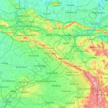
Nom : Carte topographique Teutoburger Wald, altitude, relief.
Altitude moyenne : 105 m
Altitude minimum : 31 m
Altitude maximum : 462 m
Autres cartes topographiques
Cliquez sur une carte pour visualiser sa topographie, son altitude et son relief.
Stukenbrock
Duitsland > Noordrijn-Westfalen > Kreis Gütersloh > Schloß Holte-Stukenbrock
Stukenbrock, Schloß Holte-Stukenbrock, Kreis Gütersloh, Noordrijn-Westfalen, 33758, Duitsland
Altitude moyenne : 135 m
Gütersloh
Duitsland > Noordrijn-Westfalen > Kreis Gütersloh
Gütersloh, Kreis Gütersloh, Noordrijn-Westfalen, Duitsland
Altitude moyenne : 80 m
Halle (Westf.)
Duitsland > Noordrijn-Westfalen > Kreis Gütersloh
Halle (Westf.), Kreis Gütersloh, Noordrijn-Westfalen, 33790, Duitsland
Altitude moyenne : 125 m
Rietberg
Duitsland > Noordrijn-Westfalen > Kreis Gütersloh > Rietberg > Rietberg
Rietberg, Kreis Gütersloh, Noordrijn-Westfalen, 33397, Duitsland
Altitude moyenne : 80 m