
Carte topographique Lendi
Carte interactive
Cliquez sur la carte pour afficher l’altitude.
À propos de cette carte
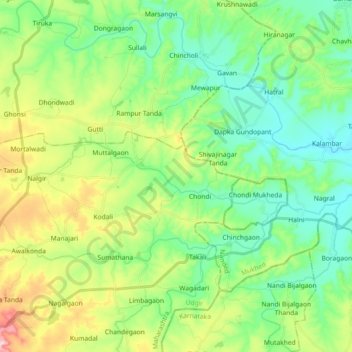
Nom : Carte topographique Lendi, altitude, relief.
Lieu : Lendi, Latur, Maharashtra, Inde (18.45897 77.15885 18.49636 77.34064)
Altitude moyenne : 477 m
Altitude minimum : 399 m
Altitude maximum : 653 m
Autres cartes topographiques
Cliquez sur une carte pour visualiser sa topographie, son altitude et son relief.
Khed
Inde > Maharashtra > Khed
Khed, Pune, Pune District, Maharashtra, 412205, Inde
Altitude moyenne : 626 m
Tarapur
Inde > Maharashtra > Tarapur
Tarapur, Palghar, Maharashtra, 401502, Inde
Altitude moyenne : 5 m
Borale
Inde > Maharashtra > Borale
Borale, Nandubar, Maharashtra, 425422, Inde
Altitude moyenne : 118 m