
Carte topographique Hamburg
Carte interactive
Cliquez sur la carte pour afficher l’altitude.
À propos de cette carte
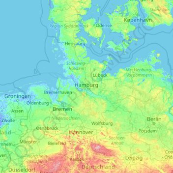
Nom : Carte topographique Hamburg, altitude, relief.
Lieu : Hamburg, Germany (50.98376 7.44991 56.10376 12.56991)
Altitude moyenne : 56 m
Altitude minimum : -6 m
Altitude maximum : 1 074 m
The neighborhoods of Neuenfelde, Cranz, Francop and Finkenwerder are part of the Altes Land (old land) region, the largest contiguous fruit-producing region in Central Europe. Neugraben-Fischbek has Hamburg's highest elevation, the Hasselbrack at 116.2 metres (381 ft) AMSL. Hamburg borders the states of Schleswig-Holstein and Lower Saxony.