
Carte topographique Bay of Plenty / Te Moana-a-Toi
Carte interactive
Cliquez sur la carte pour afficher l’altitude.
À propos de cette carte
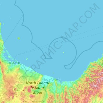
Nom : Carte topographique Bay of Plenty / Te Moana-a-Toi, altitude, relief.
Altitude moyenne : 117 m
Altitude minimum : 0 m
Altitude maximum : 1 442 m
Autres cartes topographiques
Cliquez sur une carte pour visualiser sa topographie, son altitude et son relief.
Rotorua District
Rotorua District, Bay of Plenty, New Zealand
Altitude moyenne : 404 m