
Carte topographique Klapmutskop
Carte interactive
Cliquez sur la carte pour afficher l’altitude.
À propos de cette carte
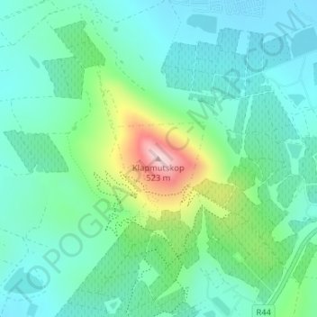
Nom : Carte topographique Klapmutskop, altitude, relief.
Altitude moyenne : 261 m
Altitude minimum : 181 m
Altitude maximum : 510 m
Autres cartes topographiques
Cliquez sur une carte pour visualiser sa topographie, son altitude et son relief.
Eerste River
RSA > Western Cape > Stellenbosch Local Municipality
Eerste River, Stellenbosch Local Municipality, Cape Winelands District Municipality, Western Cape, RSA
Altitude moyenne : 372 m
Hottentots-Holland Nature Reserve
RSA > Western Cape > Stellenbosch Local Municipality
Hottentots-Holland Nature Reserve, Boegoekloof, Stellenbosch Ward 5, Stellenbosch Local Municipality, Overberg District Municipality, Western Cape, RSA
Altitude moyenne : 557 m
Mount Rochelle Nature Reserve
RSA > Western Cape > Stellenbosch Local Municipality
Mount Rochelle Nature Reserve, R45, Stellenbosch Ward 1, Stellenbosch Local Municipality, Cape Winelands District Municipality, Western Cape, 7690, RSA
Altitude moyenne : 844 m