
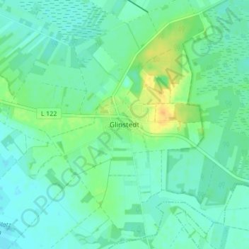
Carte topographique Glinstedt
Carte interactive
Cliquez sur la carte pour afficher l’altitude.
À propos de cette carte
Nom : Carte topographique Glinstedt, altitude, relief.
Altitude moyenne : 13 m
Altitude minimum : 5 m
Altitude maximum : 33 m
Autres cartes topographiques
Cliquez sur une carte pour visualiser sa topographie, son altitude et son relief.
Rübehorst
Deutschland > Niedersachsen > Landkreis Rotenburg (Wümme) > Gnarrenburg > Brillit
Rübehorst, Brillit, Gnarrenburg, Landkreis Rotenburg (Wümme), Niedersachsen, 27442, Deutschland
Altitude moyenne : 23 m
Fahrendorf
Deutschland > Niedersachsen > Landkreis Rotenburg (Wümme) > Gnarrenburg
Fahrendorf, Gnarrenburg, Landkreis Rotenburg (Wümme), Niedersachsen, Deutschland
Altitude moyenne : 7 m
Langenhausen
Deutschland > Niedersachsen > Landkreis Rotenburg (Wümme) > Gnarrenburg
Langenhausen, Gnarrenburg, Landkreis Rotenburg (Wümme), Niedersachsen, 27442, Deutschland
Altitude moyenne : 11 m
Kuhstedtermoor
Deutschland > Niedersachsen > Landkreis Rotenburg (Wümme) > Gnarrenburg
Kuhstedtermoor, Gnarrenburg, Landkreis Rotenburg (Wümme), Niedersachsen, Deutschland
Altitude moyenne : 7 m
Neu Kuhstedtermoor
Deutschland > Niedersachsen > Landkreis Rotenburg (Wümme) > Gnarrenburg
Neu Kuhstedtermoor, Gnarrenburg, Landkreis Rotenburg (Wümme), Niedersachsen, Deutschland
Altitude moyenne : 8 m
Oberfindorf
Deutschland > Niedersachsen > Landkreis Rotenburg (Wümme) > Gnarrenburg
Oberfindorf, Gnarrenburg, Landkreis Rotenburg (Wümme), Niedersachsen, 27442, Deutschland
Altitude moyenne : 6 m
Karlshöfenermoor
Deutschland > Niedersachsen > Landkreis Rotenburg (Wümme) > Gnarrenburg
Karlshöfenermoor, Gnarrenburg, Landkreis Rotenburg (Wümme), Niedersachsen, Deutschland
Altitude moyenne : 5 m
Klenkendorf
Deutschland > Niedersachsen > Landkreis Rotenburg (Wümme) > Gnarrenburg
Klenkendorf, Gnarrenburg, Landkreis Rotenburg (Wümme), Niedersachsen, Deutschland
Altitude moyenne : 9 m
Kuhstedt
Deutschland > Niedersachsen > Landkreis Rotenburg (Wümme) > Gnarrenburg
Kuhstedt, Gnarrenburg, Landkreis Rotenburg (Wümme), Niedersachsen, 27442, Deutschland
Altitude moyenne : 22 m
Brillit
Deutschland > Niedersachsen > Landkreis Rotenburg (Wümme) > Gnarrenburg
Brillit, Gnarrenburg, Landkreis Rotenburg (Wümme), Niedersachsen, 27442, Deutschland
Altitude moyenne : 28 m
Karlshöfen
Deutschland > Niedersachsen > Landkreis Rotenburg (Wümme) > Gnarrenburg
Karlshöfen, Gnarrenburg, Landkreis Rotenburg (Wümme), Niedersachsen, 27442, Deutschland
Altitude moyenne : 9 m
Forstort-Anfang
Deutschland > Niedersachsen > Landkreis Rotenburg (Wümme) > Gnarrenburg
Forstort-Anfang, Gnarrenburg, Landkreis Rotenburg (Wümme), Niedersachsen, Deutschland
Altitude moyenne : 13 m