
Carte topographique Grenfell
Cliquez sur la carte pour afficher l’altitude.
À propos de cette carte
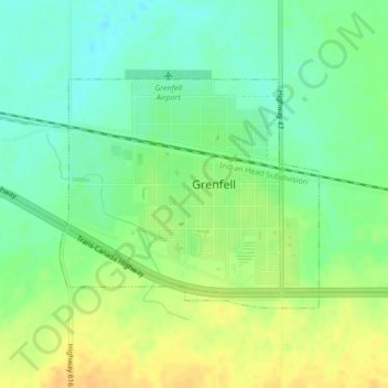
Nom : Carte topographique Grenfell, altitude, relief.
Lieu : Grenfell, Saskatchewan, S0G 2B0, Canada (50.40269 -102.94684 50.41865 -102.91854)
Altitude moyenne : 601 m
Altitude minimum : 587 m
Altitude maximum : 615 m
Autres cartes topographiques
Cliquez sur une carte pour visualiser sa topographie, son altitude et son relief.
Little Fishing Lake
Canada > Saskatchewan > Division No. 17 > Loon Lake No. 561
Altitude moyenne : 617 m
McClean Lake
Canada > Saskatchewan > Division No. 18 > Unorganized Division No. 18
Altitude moyenne : 440 m
La Loche
Canada > Saskatchewan > Northern Saskatchewan Administration District > La Loche
Altitude moyenne : 447 m
Pelican Narrows
Canada > Saskatchewan > Northern Saskatchewan Administration District > Pelican Narrows
Altitude moyenne : 321 m