
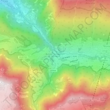
Carte topographique Runcadic - Runggaditsch - Roncadizza
Carte interactive
Cliquez sur la carte pour afficher l’altitude.
À propos de cette carte
Nom : Carte topographique Runcadic - Runggaditsch - Roncadizza, altitude, relief.
Altitude moyenne : 1 520 m
Altitude minimum : 952 m
Altitude maximum : 2 167 m
Autres cartes topographiques
Cliquez sur une carte pour visualiser sa topographie, son altitude et son relief.
Seis am Schlern - Siusi allo Sciliar
Italy > Trentino-Alto Adige/Südtirol > South Tyrol > Kastelruth - Castelrotto
Seis am Schlern - Siusi allo Sciliar, Kastelruth - Castelrotto, Salten-Schlern - Salto-Sciliar, South Tyrol, Trentino-Alto Adige/Südtirol, Italy
Altitude moyenne : 1 211 m
Tiosels
Italy > Trentino-Alto Adige/Südtirol > South Tyrol > Kastelruth - Castelrotto > Kastelruth - Ciastel - Castelrotto > Tiosels
Tiosels, Kastelruth - Ciastel - Castelrotto, Kastelruth - Castelrotto, Salten-Schlern - Salto-Sciliar, South Tyrol, Trentino-Alto Adige/Südtirol, Italy
Altitude moyenne : 1 275 m
Kastelruth - Ciastel - Castelrotto
Italy > Trentino-Alto Adige/Südtirol > South Tyrol > Kastelruth - Castelrotto > Kastelruth - Ciastel - Castelrotto
Kastelruth - Ciastel - Castelrotto, Kastelruth - Castelrotto, Salten-Schlern - Salto-Sciliar, South Tyrol, Trentino-Alto Adige/Südtirol, Italy
Altitude moyenne : 1 118 m
Compatsch
Italy > Trentino-Alto Adige/Südtirol > South Tyrol > Kastelruth - Castelrotto
Compatsch, Kastelruth - Castelrotto, Salten-Schlern - Salto-Sciliar, South Tyrol, Trentino-Alto Adige/Südtirol, Italy
Altitude moyenne : 1 859 m