
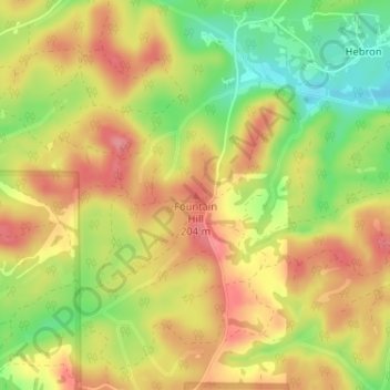
Carte topographique Fountain Hill
Carte interactive
Cliquez sur la carte pour afficher l’altitude.
À propos de cette carte
Nom : Carte topographique Fountain Hill, altitude, relief.
Lieu : Fountain Hill, Bibb County, Alabama, United States (33.15729 -87.08116 33.15739 -87.08106)
Altitude moyenne : 166 m
Altitude minimum : 113 m
Altitude maximum : 205 m
Autres cartes topographiques
Cliquez sur une carte pour visualiser sa topographie, son altitude et son relief.
East Centreville
United States > Alabama > Bibb County > Centreville
East Centreville, Centreville, Bibb County, Alabama, 35042, United States
Altitude moyenne : 77 m
Lawley
United States > Alabama > Bibb County
Lawley, Bibb County, Alabama, 35793, United States
Altitude moyenne : 139 m
Centreville
United States > Alabama > Bibb County
Centreville, Bibb County, Alabama, 35042, United States
Altitude moyenne : 93 m
Tucker
United States > Alabama > Bibb County > Tucker
Tucker, Bibb County, Alabama, United States
Altitude moyenne : 150 m
Randolph
United States > Alabama > Bibb County > Randolph
Randolph, Bibb County, Alabama, United States
Altitude moyenne : 162 m
Schultz Creek
United States > Alabama > Bibb County
Schultz Creek, Bibb County, Alabama, United States
Altitude moyenne : 115 m
Sand Mountain
United States > Alabama > Bibb County
Sand Mountain, Bibb County, Alabama, United States
Altitude moyenne : 156 m
Brent
United States > Alabama > Bibb County > Brent
Brent, Bibb County, Alabama, 35034, United States
Altitude moyenne : 84 m