
Carte topographique Datong
Carte interactive
Cliquez sur la carte pour afficher l’altitude.
À propos de cette carte
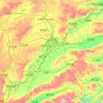
Nom : Carte topographique Datong, altitude, relief.
Lieu : Datong, Shanxi, China (39.04845 112.57067 40.74496 114.56551)
Altitude moyenne : 1 339 m
Altitude minimum : 690 m
Altitude maximum : 3 029 m
Datong is a prefecture-level city in northern Shanxi Province in the People's Republic of China. It is located in the Datong Basin at an elevation of 1,040 metres (3,410 ft) and borders Inner Mongolia to the north and west and Hebei to the east. As of the 2020 census, it had a population of 3,105,591 of whom 1,790,452 lived in the built-up (or metro) area made of the 2 out 4 urban districts of Pingcheng and Yungang as Yunzhou and Xinrong are not conurbated yet.
Autres cartes topographiques
Cliquez sur une carte pour visualiser sa topographie, son altitude et son relief.
Pingyao County
China > Shanxi > Jinzhong City
Pingyao County, Jinzhong City, Shanxi, 031100, China
Altitude moyenne : 1 128 m
Hejin
China > Shanxi > Hejin City > Chengqu Subdistrict
Hejin, Chengqu Subdistrict, Hejin City, Yuncheng City, Shanxi, 043300, China
Altitude moyenne : 529 m
Linyi
China > Shanxi > Linyi County
Linyi, Linyi County, Yuncheng City, Shanxi, China
Altitude moyenne : 455 m
Shiba
China > Shanxi > Ningwu County > Shiba
Shiba, Ningwu County, Xinzhou City, Shanxi, China
Altitude moyenne : 1 599 m
Pingcheng District
China > Shanxi > Pingcheng District
Datong, Pingcheng District, Datong City, Shanxi, 037004, China
Altitude moyenne : 1 149 m
Gulou Subdistrict
China > Shanxi > Gulou Subdistrict
Gulou Subdistrict, Huozhou City, Linfen Shi, Shanxi, China
Altitude moyenne : 560 m
Yuncheng
China > Shanxi > Dongcheng Subdistrict
Yuncheng, Dongcheng Subdistrict, Yanhu District, Yuncheng City, Shanxi, 044031, China
Altitude moyenne : 478 m