
Carte topographique Ljubljana
Carte interactive
Cliquez sur la carte pour afficher l’altitude.
À propos de cette carte
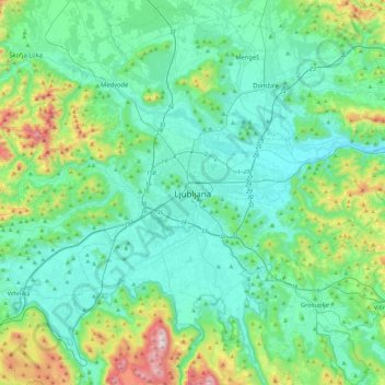
Nom : Carte topographique Ljubljana, altitude, relief.
Lieu : Ljubljana, Upravna Enota Ljubljana, 1000, Slovenia (45.88998 14.34686 46.20998 14.66686)
Altitude moyenne : 412 m
Altitude minimum : 251 m
Altitude maximum : 1 094 m
Ljubljana has an elevation of 295 meters (968 ft) The city centre, located along the Ljubljanica River, has an elevation of 298 meters (978 ft). Ljubljana Castle, which sits atop Castle Hill (Grajski grič) south of the city centre, has an elevation of 366 meters (1,201 ft). The highest point of the city, called Grmada, reaches 676 meters (2,218 ft), 3 meters (9.8 ft) more than the nearby Mount Saint Mary (Šmarna gora) peak, a popular hiking destination. These are located in the northern part of the city.
Autres cartes topographiques
Cliquez sur une carte pour visualiser sa topographie, son altitude et son relief.