Géolocaliser

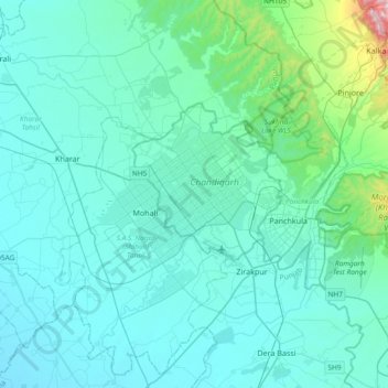
Carte topographique Chandigarh

Cliquez sur la carte pour afficher l’altitude.

Chandigarh

Chandigarh is located by the foothills of the Shivalik Range of the Himalayas in northwest India. It covers an area of approximately 114 km2. It borders the states of Punjab and Haryana. The exact geographic coordinates of Chandigarh are 30°44′N 76°47′E / 30.74°N 76.79°E / 30.74; 76.79. It has an average elevation of 321 metres (1053 ft).

Wikipedia (CC-BY-SA 3.0)

À propos de cette carte

Nom : Carte topographique Chandigarh, altitude, relief.

Lieu : Chandigarh, 160018, India (30.57344 76.61971 30.89344 76.93971)

Altitude moyenne : 378 m

Altitude minimum : 276 m

Altitude maximum : 1 651 m

Autres cartes topographiques

Cliquez sur une carte pour visualiser sa topographie, son altitude et son relief.

New Lake Sector 42

India > Chandigarh > Chandigarh > Buterla

Altitude moyenne : 329 m

Ward 11

India > Chandigarh > Chandigarh

Altitude moyenne : 328 m

Sector 25 West

India > Chandigarh > Chandigarh

Altitude moyenne : 342 m

Sector 49

India > Chandigarh > Chandigarh > Chandigarh

Altitude moyenne : 318 m

Sector 10

India > Chandigarh > Chandigarh > Chandigarh

Altitude moyenne : 358 m

Ward 13

India > Chandigarh > Chandigarh

Altitude moyenne : 320 m

Équipez-vous pour votre prochaine aventure :

🔦Mini lampe LED porte-clés - Éclairage d'appoint toujours à portée de main
🎒Housse de pluie pour sac à dos - Protection supplémentaire pour garder votre contenu au sec
🩳Pantalons de randonnée - Pantalons résistants et confortables
🖼️Art mural topographique - Décoration élégante représentant des reliefs célèbres
📦Rangement matériel outdoor - Organisation de l'équipement

En tant que Partenaire Amazon, ce site perçoit une commission sur les achats éligibles sans surcoût pour vous.