
Carte topographique Pagbanganan River
Carte interactive
Cliquez sur la carte pour afficher l’altitude.
À propos de cette carte
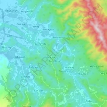
Nom : Carte topographique Pagbanganan River, altitude, relief.
Altitude moyenne : 145 m
Altitude minimum : 0 m
Altitude maximum : 690 m
Autres cartes topographiques
Cliquez sur une carte pour visualiser sa topographie, son altitude et son relief.
Kilim
Philippines > Leyte > Baybay
Kilim, Baybay, Leyte 5th District, Leyte, Eastern Visayas, 6521, Philippines
Altitude moyenne : 8 m