
Carte topographique Khánh Vĩnh District
Carte interactive
Cliquez sur la carte pour afficher l’altitude.
À propos de cette carte
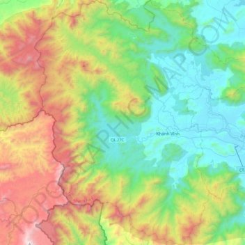
Nom : Carte topographique Khánh Vĩnh District, altitude, relief.
Lieu : Khánh Vĩnh District, Khánh Hoà Province, Vietnam (12.08707 108.67101 12.50488 109.06701)
Altitude moyenne : 725 m
Altitude minimum : 6 m
Altitude maximum : 2 270 m
Autres cartes topographiques
Cliquez sur une carte pour visualiser sa topographie, son altitude et son relief.
Nha Trang
Vietnam > Khanh Hoa province > Nha Trang
Nha Trang, Khánh Hoà Province, Vietnam
Altitude moyenne : 118 m
Nha Trang
Vietnam > Khanh Hoa province > Nha Trang
Nha Trang, Khanh Hoa province, 48058, Vietnam
Altitude moyenne : 113 m