
Carte topographique Shwebo District
Carte interactive
Cliquez sur la carte pour afficher l’altitude.
À propos de cette carte
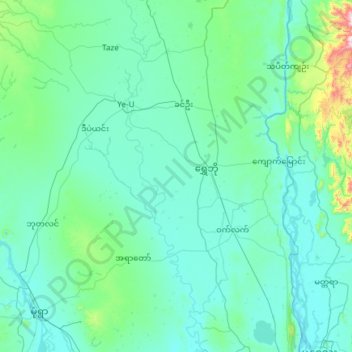
Nom : Carte topographique Shwebo District, altitude, relief.
Lieu : Shwebo District, Sagaing, Myanmar (22.17475 94.81616 22.90471 96.01015)
Altitude moyenne : 151 m
Altitude minimum : 61 m
Altitude maximum : 1 358 m
Autres cartes topographiques
Cliquez sur une carte pour visualiser sa topographie, son altitude et son relief.
Shwebo Township
Myanmar > Sagaing > Shwebo District > Shwebo Township
Shwebo Township, Shwebo District, Sagaing, Myanmar
Altitude moyenne : 113 m