Géolocaliser

Carte topographique Pratapgarh

Cliquez sur la carte pour afficher l’altitude.

Pratapgarh

Pratapgarh District is a newly constituted district in Rajasthan state. it came into existence on 26 January 2008, as the 33rd district of Rajasthan. Pratapgarh is located at 24.03° N 74.78° E. It has an average elevation of 491 metres (1610 feet). It is said to be the second highest place in Rajasthan after Mount Abu.

Wikipedia (CC-BY-SA 3.0)

À propos de cette carte

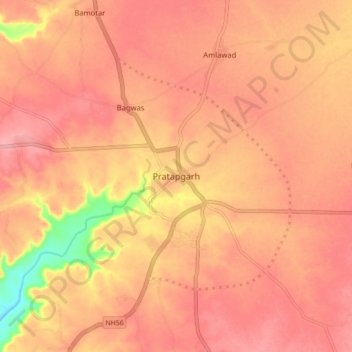
Nom : Carte topographique Pratapgarh, altitude, relief.

Lieu : Pratapgarh, Pratapgarh Tehsil, Pratapgarh, Rajasthan, 312605, India (23.99335 74.74013 24.07335 74.82013)

Altitude moyenne : 503 m

Altitude minimum : 428 m

Altitude maximum : 529 m

Équipez-vous pour votre prochaine aventure :

🗺️Carte du monde à gratter - Cadeau idéal pour suivre ses explorations passées
👣Semelles de remplacement confort - Améliorez le soutien de vos bottes pour les longues marches
🔦Lanterne de camping LED - Éclairage d'ambiance pour l'intérieur de la tente
🧴Crèmes solaires outdoor - Protection UV en randonnée
🧰Outils multifonctions - Polyvalence et compacité

En tant que Partenaire Amazon, ce site perçoit une commission sur les achats éligibles sans surcoût pour vous.