
Carte topographique Carricknameeltage
Carte interactive
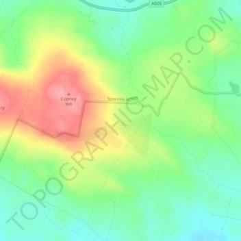
Cliquez sur la carte pour afficher l’altitude.
À propos de cette carte
Nom : Carte topographique Carricknameeltage, altitude, relief.
Altitude moyenne : 212 m
Altitude minimum : 168 m
Altitude maximum : 276 m
Autres cartes topographiques
Cliquez sur une carte pour visualiser sa topographie, son altitude et son relief.
Drumquin
United Kingdom > Northern Ireland > County Tyrone
Drumquin, County Tyrone, Northern Ireland, BT78 4SB, United Kingdom
Altitude moyenne : 97 m
Loughmacrory
United Kingdom > Northern Ireland > County Tyrone > Loughmacrory
Loughmacrory, County Tyrone, Ulster, Northern Ireland, BT79 9LG, United Kingdom
Altitude moyenne : 190 m
Carricknagapple
United Kingdom > Northern Ireland > County Tyrone
Carricknagapple, County Tyrone, Ulster, Northern Ireland, BT79 9AF, United Kingdom
Altitude moyenne : 212 m
Mullaghcarn
United Kingdom > Northern Ireland > County Tyrone
Mullaghcarn, County Tyrone, Ulster, Northern Ireland, BT79 8PU, United Kingdom
Altitude moyenne : 386 m
Rooskey
United Kingdom > Northern Ireland > County Tyrone
Rooskey, County Tyrone, Ulster, Northern Ireland, BT78 3EE, United Kingdom
Altitude moyenne : 133 m
Drumshanbo
United Kingdom > Northern Ireland > County Tyrone
Drumshanbo, County Tyrone, Northern Ireland, BT78 4PT, United Kingdom
Altitude moyenne : 84 m
Claggan
United Kingdom > Northern Ireland > County Tyrone
Claggan, County Tyrone, Ulster, Northern Ireland, United Kingdom
Altitude moyenne : 84 m
Beaghmore
United Kingdom > Northern Ireland > County Tyrone
Beaghmore, Blackrock Road, County Tyrone, Northern Ireland, BT80 9NT, United Kingdom
Altitude moyenne : 190 m
Mulnagore
United Kingdom > Northern Ireland > County Tyrone
Mulnagore, County Tyrone, Ulster, Northern Ireland, United Kingdom
Altitude moyenne : 86 m
Mullaghmenagh
United Kingdom > Northern Ireland > County Tyrone
Mullaghmenagh, County Tyrone, Northern Ireland, United Kingdom
Altitude moyenne : 370 m
Clogh
United Kingdom > Northern Ireland > County Tyrone
Clogh, County Tyrone, Northern Ireland, BT81 7XF, United Kingdom
Altitude moyenne : 205 m
Coagh
United Kingdom > Northern Ireland > County Tyrone > Coagh
Coagh, County Tyrone, Northern Ireland, BT80 0DW, United Kingdom
Altitude moyenne : 43 m
Newtownstewart
United Kingdom > Northern Ireland > County Tyrone > Newtownstewart
Newtownstewart, County Tyrone, Northern Ireland, BT78 4AQ, United Kingdom
Altitude moyenne : 87 m
Castlederg
United Kingdom > Northern Ireland > County Tyrone
Castlederg, County Tyrone, Ulster, Northern Ireland, BT81 7AR, United Kingdom
Altitude moyenne : 78 m
Dungannon
United Kingdom > Northern Ireland > County Tyrone > Dungannon
Dungannon, County Tyrone, Northern Ireland, BT71 7AA, United Kingdom
Altitude moyenne : 76 m
Galbally
United Kingdom > Northern Ireland > County Tyrone
Galbally, County Tyrone, Ulster, Northern Ireland, BT70 2NX, United Kingdom
Altitude moyenne : 119 m
Moy
United Kingdom > Northern Ireland > County Tyrone
Moy, County Tyrone, Northern Ireland, BT71 7SG, United Kingdom
Altitude moyenne : 26 m