
Faire un don
Équipez-vous pour votre prochaine aventure :
En tant que Partenaire Amazon, ce site perçoit une commission sur les achats éligibles sans surcoût pour vous.
Carte topographique Condrieu
Cliquez sur la carte pour afficher l’altitude.
Faire un don
Équipez-vous pour votre prochaine aventure :
En tant que Partenaire Amazon, ce site perçoit une commission sur les achats éligibles sans surcoût pour vous.
Condrieu
La superficie de la commune est de 921 hectares ; son altitude varie de 146 à 460 mètres.
Faire un don
Équipez-vous pour votre prochaine aventure :
En tant que Partenaire Amazon, ce site perçoit une commission sur les achats éligibles sans surcoût pour vous.
À propos de cette carte
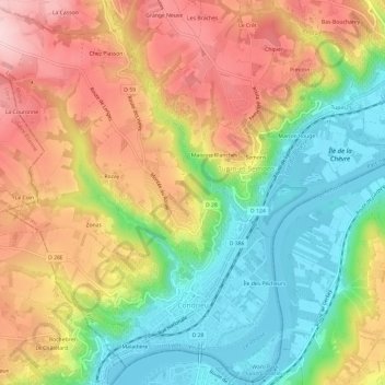
Nom : Carte topographique Condrieu, altitude, relief.
Altitude moyenne : 266 m
Altitude minimum : 141 m
Altitude maximum : 406 m
Faire un don
Équipez-vous pour votre prochaine aventure :
En tant que Partenaire Amazon, ce site perçoit une commission sur les achats éligibles sans surcoût pour vous.
Autres cartes topographiques
Cliquez sur une carte pour visualiser sa topographie, son altitude et son relief.
Plan d'Eau de Bordelan
France > Auvergne-Rhône-Alpes > Rhône > Villefranche-sur-Saône
Altitude moyenne : 186 m
Signal de Saint-André
France > Auvergne-Rhône-Alpes > Rhône > Saint-André-la-Côte
Le signal de Saint-André est un sommet situé sur la commune de Saint-André-la-Côte dans le département français du Rhône, sur la ligne de crêtes principale des monts du Lyonnais. Avec 934 mètres d'altitude, il est seulement dépassé par le crêt Malherbe. Il est situé à 20 kilomètres à l'ouest de Lyon.
Altitude moyenne : 780 m
Faire un don
Équipez-vous pour votre prochaine aventure :
En tant que Partenaire Amazon, ce site perçoit une commission sur les achats éligibles sans surcoût pour vous.
Château de Pizay
France > Auvergne-Rhône-Alpes > Rhône > Belleville-en-Beaujolais > Saint-Jean-d'Ardières > Pizay
Altitude moyenne : 223 m
Faire un don
Équipez-vous pour votre prochaine aventure :
En tant que Partenaire Amazon, ce site perçoit une commission sur les achats éligibles sans surcoût pour vous.
La Maletière
France > Auvergne-Rhône-Alpes > Rhône > Saint-Clément-sur-Valsonne
Altitude moyenne : 475 m
Faire un don
Équipez-vous pour votre prochaine aventure :
En tant que Partenaire Amazon, ce site perçoit une commission sur les achats éligibles sans surcoût pour vous.
Faire un don
Équipez-vous pour votre prochaine aventure :
En tant que Partenaire Amazon, ce site perçoit une commission sur les achats éligibles sans surcoût pour vous.
Faire un don
Équipez-vous pour votre prochaine aventure :
En tant que Partenaire Amazon, ce site perçoit une commission sur les achats éligibles sans surcoût pour vous.
Les Arnauds du Haut
France > Auvergne-Rhône-Alpes > Rhône > Lamure-sur-Azergues
Altitude moyenne : 490 m
Faire un don
Équipez-vous pour votre prochaine aventure :
En tant que Partenaire Amazon, ce site perçoit une commission sur les achats éligibles sans surcoût pour vous.
Les Coasses
France > Auvergne-Rhône-Alpes > Rhône > Val d'Oingt > Le Bois-d'Oingt
Altitude moyenne : 354 m
Col du Chêne
France > Auvergne-Rhône-Alpes > Rhône > Sainte-Paule > Le Châtoux
Altitude moyenne : 623 m
Faire un don
Équipez-vous pour votre prochaine aventure :
En tant que Partenaire Amazon, ce site perçoit une commission sur les achats éligibles sans surcoût pour vous.
Faire un don
Équipez-vous pour votre prochaine aventure :
En tant que Partenaire Amazon, ce site perçoit une commission sur les achats éligibles sans surcoût pour vous.
Le Mincieux
France > Auvergne-Rhône-Alpes > Rhône > Beauvallon > Saint-Jean-de-Touslas
Altitude moyenne : 296 m
Faire un don
Équipez-vous pour votre prochaine aventure :
En tant que Partenaire Amazon, ce site perçoit une commission sur les achats éligibles sans surcoût pour vous.
La Grosne Orientale
France > Auvergne-Rhône-Alpes > Rhône > Deux-Grosnes > Ouroux
Altitude moyenne : 568 m
Bois de la Salle
France > Auvergne-Rhône-Alpes > Rhône > Juliénas > Bois de la Salle
Altitude moyenne : 338 m
Faire un don
Équipez-vous pour votre prochaine aventure :
En tant que Partenaire Amazon, ce site perçoit une commission sur les achats éligibles sans surcoût pour vous.
Faire un don
Équipez-vous pour votre prochaine aventure :
En tant que Partenaire Amazon, ce site perçoit une commission sur les achats éligibles sans surcoût pour vous.
Sainte-Catherine
France > Auvergne-Rhône-Alpes > Rhône > Sainte-Catherine > Sainte-Catherine
Sainte Catherine est une commune française située à 680 m d’altitude dans le département du Rhône, en région Auvergne-Rhone-Alpes.
Altitude moyenne : 723 m
Lamure-sur-Azergues
France > Auvergne-Rhône-Alpes > Rhône > Lamure-sur-Azergues > Lamure-sur-Azergues
Situé à une cinquantaine de kilomètres au nord-ouest de l'agglomération lyonnaise, le village de Lamure-sur-Azergues est en plein cœur du Beaujolais vert. Un territoire où se marient espaces boisés et agricoles pour former des paysages bien agréables à l'œil. Le village de Lamure est niché au cœur…
Altitude moyenne : 526 m
Saint-Pierre-la-Palud
France > Auvergne-Rhône-Alpes > Rhône > Saint-Pierre-la-Palud > Saint-Pierre-la-Palud
Altitude moyenne : 413 m
Faire un don
Équipez-vous pour votre prochaine aventure :
En tant que Partenaire Amazon, ce site perçoit une commission sur les achats éligibles sans surcoût pour vous.
Faire un don
Équipez-vous pour votre prochaine aventure :
En tant que Partenaire Amazon, ce site perçoit une commission sur les achats éligibles sans surcoût pour vous.
La Savoie
France > Auvergne-Rhône-Alpes > Rhône > Vindry-sur-Turdine > Pontcharra-sur-Turdine
Altitude moyenne : 392 m
Faire un don
Équipez-vous pour votre prochaine aventure :
En tant que Partenaire Amazon, ce site perçoit une commission sur les achats éligibles sans surcoût pour vous.
Faire un don
Équipez-vous pour votre prochaine aventure :
En tant que Partenaire Amazon, ce site perçoit une commission sur les achats éligibles sans surcoût pour vous.
Guillaume
France > Auvergne-Rhône-Alpes > Rhône > Saint-Laurent-de-Vaux > Le Cholly
Altitude moyenne : 568 m
Faire un don
Équipez-vous pour votre prochaine aventure :
En tant que Partenaire Amazon, ce site perçoit une commission sur les achats éligibles sans surcoût pour vous.
Faire un don
Équipez-vous pour votre prochaine aventure :
En tant que Partenaire Amazon, ce site perçoit une commission sur les achats éligibles sans surcoût pour vous.
Le Colin
France > Auvergne-Rhône-Alpes > Rhône > Thizy-les-Bourgs > Bourg-de-Thizy
Altitude moyenne : 445 m
Faire un don
Équipez-vous pour votre prochaine aventure :
En tant que Partenaire Amazon, ce site perçoit une commission sur les achats éligibles sans surcoût pour vous.
La Croix Saint-Jean
France > Auvergne-Rhône-Alpes > Rhône > Thizy-les-Bourgs > Mardore > La Montagne
Altitude moyenne : 606 m
Faire un don
Équipez-vous pour votre prochaine aventure :
En tant que Partenaire Amazon, ce site perçoit une commission sur les achats éligibles sans surcoût pour vous.
La Terrasse de Chiroubles
France > Auvergne-Rhône-Alpes > Rhône > Chiroubles > Les Saignes
Altitude moyenne : 634 m
Faire un don
Équipez-vous pour votre prochaine aventure :
En tant que Partenaire Amazon, ce site perçoit une commission sur les achats éligibles sans surcoût pour vous.
Faire un don
Équipez-vous pour votre prochaine aventure :
En tant que Partenaire Amazon, ce site perçoit une commission sur les achats éligibles sans surcoût pour vous.
Les Charbonniers
France > Auvergne-Rhône-Alpes > Rhône > Deux-Grosnes > Monsols
Altitude moyenne : 646 m
Faire un don
Équipez-vous pour votre prochaine aventure :
En tant que Partenaire Amazon, ce site perçoit une commission sur les achats éligibles sans surcoût pour vous.
Faire un don
Équipez-vous pour votre prochaine aventure :
En tant que Partenaire Amazon, ce site perçoit une commission sur les achats éligibles sans surcoût pour vous.
Château de Montlys
France > Auvergne-Rhône-Alpes > Rhône > Saint-Cyr-sur-le-Rhône > Le Mont
Altitude moyenne : 225 m
Faire un don
Équipez-vous pour votre prochaine aventure :
En tant que Partenaire Amazon, ce site perçoit une commission sur les achats éligibles sans surcoût pour vous.
Moulin à Vent
France > Auvergne-Rhône-Alpes > Rhône > Saint-Étienne-la-Varenne
Altitude moyenne : 318 m
Faire un don
Équipez-vous pour votre prochaine aventure :
En tant que Partenaire Amazon, ce site perçoit une commission sur les achats éligibles sans surcoût pour vous.