
Carte topographique Eureka
Carte interactive
Cliquez sur la carte pour afficher l’altitude.
À propos de cette carte
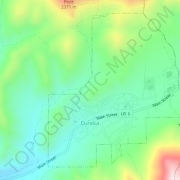
Nom : Carte topographique Eureka, altitude, relief.
Lieu : Eureka, Juab County, Utah, United States (39.94749 -112.12847 39.97063 -112.09986)
Altitude moyenne : 2 048 m
Altitude minimum : 1 894 m
Altitude maximum : 2 396 m
Eureka is located in northern Juab County at 39°57′18″N 112°6′59″W / 39.95500°N 112.11639°W / 39.95500; -112.11639 (39.954974, -112.116364). It sits in the East Tintic Mountains at an elevation of 6,430 feet (1,960 m) above sea level. The northeast boundary of the city is the Utah County line, following the height of land. 7,828-foot (2,386 m) Packard Peak is to the north, while 8,048-foot (2,453 m) Godiva Mountain and 7,917-foot (2,413 m) Eureka Ridge are to the south.
Autres cartes topographiques
Cliquez sur une carte pour visualiser sa topographie, son altitude et son relief.
Desert Mountain
United States > Utah > Juab County
Desert Mountain, Juab County, Utah, United States
Altitude moyenne : 1 673 m
Topaz Mountain
United States > Utah > Juab County
Topaz Mountain, Juab County, Utah, United States
Altitude moyenne : 1 895 m
Nephi
United States > Utah > Juab County > Nephi
Nephi, Juab County, Utah, 84648, United States
Altitude moyenne : 1 651 m
Nephi
United States > Utah > Juab County
Nephi, Juab County, Utah, 84648, United States
Altitude moyenne : 1 637 m