
Carte topographique Ripatransone
Carte interactive
Cliquez sur la carte pour afficher l’altitude.
Ripatransone
The climate of Ripatransone is close to the Mediterranean: winters are colder and, although the hilly altitude limits the frequency of snowfalls, they occur more or less annually and can also be intense and lasting. Summers are generally cooler and more airy, with temperatures that are still quite high.
À propos de cette carte
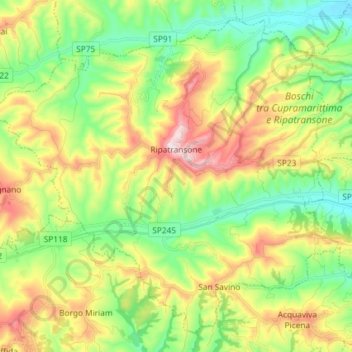
Nom : Carte topographique Ripatransone, altitude, relief.
Lieu : Ripatransone, Ascoli Piceno, Marche, 63065, Italy (42.94034 13.68345 43.03569 13.82945)
Altitude moyenne : 197 m
Altitude minimum : 13 m
Altitude maximum : 495 m
Autres cartes topographiques
Cliquez sur une carte pour visualiser sa topographie, son altitude et son relief.