
Carte topographique Blackwell Glacier
Carte interactive
Cliquez sur la carte pour afficher l’altitude.
À propos de cette carte
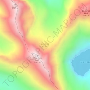
Nom : Carte topographique Blackwell Glacier, altitude, relief.
Altitude moyenne : 2 114 m
Altitude minimum : 1 560 m
Altitude maximum : 2 635 m
Autres cartes topographiques
Cliquez sur une carte pour visualiser sa topographie, son altitude et son relief.
Ahern Glacier
Ahern Glacier, Highline Trail, Flathead County, Montana, USA
Altitude moyenne : 2 214 m
Wolf Glacier
Wolf Glacier, Goose Lake Jeep Trail, Park County, Montana, USA
Altitude moyenne : 3 144 m
Jackson Peak
Jackson Peak, Lewis and Clark County, Montana, USA
Altitude moyenne : 1 271 m
Two Ocean Glacier
Two Ocean Glacier, Logging Lake, Flathead County, Montana, USA
Altitude moyenne : 2 331 m
Chaney Glacier
Chaney Glacier, Highline Trail, Flathead County, Montana, USA
Altitude moyenne : 2 169 m
Weasel Collar Glacier
Weasel Collar Glacier, Bowman Lake, Flathead County, Montana, USA
Altitude moyenne : 2 290 m
North Swiftcurrent Glacier
North Swiftcurrent Glacier, Swiftcurrent Lookout Trail, Flathead County, Montana, USA
Altitude moyenne : 2 051 m
Running Crane Lake
Running Crane Lake, Pitamakan Pass, Glacier County, Montana, USA
Altitude moyenne : 2 333 m
Hudson Glacier
USA > Montana > Wurtz Hill
Hudson Glacier, Boulder Pass, Wurtz Hill, Flathead County, Montana, USA
Altitude moyenne : 2 079 m
Sperry Glacier
Sperry Glacier, Sperry Lake, Flathead County, Montana, USA
Altitude moyenne : 2 382 m
Grasshopper Glacier
Grasshopper Glacier, Carbon County, Montana, USA
Altitude moyenne : 3 407 m
Snowbank Glacier
Snowbank Glacier, Carbon County, Montana, USA
Altitude moyenne : 3 376 m
Old Sun Glacier
Old Sun Glacier, Stoney Indian Pass, Glacier County, Montana, USA
Altitude moyenne : 2 285 m
Sundance Glacier
Sundance Glacier, Carbon County, Montana, USA
Altitude moyenne : 3 488 m
Boulder Glacier
USA > Montana > Wurtz Hill
Boulder Glacier, Boulder Pass, Wurtz Hill, Flathead County, Montana, USA
Altitude moyenne : 2 105 m
Gem Glacier
Gem Glacier, Highline Trail, Flathead County, Montana, USA
Altitude moyenne : 2 150 m
Whitecrow Glacier
Whitecrow Glacier, Stoney Indian Pass, Glacier County, Montana, USA
Altitude moyenne : 2 339 m
Red Eagle Glacier
Red Eagle Glacier, Nyack Creek, Nyack, Flathead County, Montana, USA
Altitude moyenne : 2 100 m
Vulture Glacier
Vulture Glacier, Logging Lake, Flathead County, Montana, USA
Altitude moyenne : 2 381 m
Kintla Glacier
USA > Montana > Wurtz Hill
Kintla Glacier, Boulder Pass, Wurtz Hill, Flathead County, Montana, USA
Altitude moyenne : 2 336 m
Independence Peak
Independence Peak, Lincoln County, Montana, USA
Altitude moyenne : 1 895 m
Thunderbird Glacier
USA > Montana > Wurtz Hill
Thunderbird Glacier, Boulder Pass, Wurtz Hill, Flathead County, Montana, USA
Altitude moyenne : 2 162 m
Glacier National Park
Glacier National Park, Sperry Lake, Flathead County, Montana, USA
Altitude moyenne : 1 594 m
Pryor Mountains Historical Marker
USA > Montana > Berts Trailer Court
Pryor Mountains Historical Marker, Berts Trailer Court, Carbon County, Montana, USA
Altitude moyenne : 1 097 m
Young Man Lake
Young Man Lake, Oldman Lake, Glacier County, Montana, USA
Altitude moyenne : 2 169 m
Pumpelly Glacier
Pumpelly Glacier, Jackson Glacier, Glacier County, Montana, USA
Altitude moyenne : 2 326 m
Phantom Glacier
Phantom Glacier, Clarks Fork Trail, Carbon County, Montana, USA
Altitude moyenne : 3 248 m
Piegan Glacier
Piegan Glacier, Piegan Pass Trail, Glacier County, Montana, USA
Altitude moyenne : 2 222 m
Salamander Glacier
Salamander Glacier, Garden Wall Trail, Flathead County, Montana, USA
Altitude moyenne : 2 102 m
Baby Glacier
Baby Glacier, Bowman Lake, Flathead County, Montana, USA
Altitude moyenne : 2 009 m
Swiftcurrent Glacier
Swiftcurrent Glacier, Garden Wall Trail, Flathead County, Montana, USA
Altitude moyenne : 2 062 m
Beartooth Glacier
Beartooth Glacier, Carbon County, Montana, USA
Altitude moyenne : 3 240 m
Devils Slide
Devils Slide, Many Glacier Road, Babb, Glacier County, Montana, 59411, USA
Altitude moyenne : 1 502 m
Cabinet Mountains Wilderness Area
Cabinet Mountains Wilderness Area, Sanders County, Montana, USA
Altitude moyenne : 1 247 m