
Carte topographique Harricott
Cliquez sur la carte pour afficher l’altitude.
À propos de cette carte
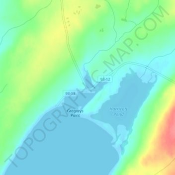
Nom : Carte topographique Harricott, altitude, relief.
Lieu : Harricott, Newfoundland, Newfoundland and Labrador, Canada (47.16437 -53.54594 47.18437 -53.52594)
Altitude moyenne : 19 m
Altitude minimum : -7 m
Altitude maximum : 69 m
Autres cartes topographiques
Cliquez sur une carte pour visualiser sa topographie, son altitude et son relief.
Clarenville
Canada > Newfoundland and Labrador
The Clarenville area has many of the physical features characteristic of the East Coast of Newfoundland and has a marine climate. It lies along the coastal slopes which rise from the Atlantic Ocean towards the interior central plateau of the island. The dominating physical feature is a ridge of broken peaks…
Altitude moyenne : 102 m