
Carte topographique Mapleton
Cliquez sur la carte pour afficher l’altitude.
À propos de cette carte
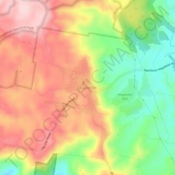
Nom : Carte topographique Mapleton, altitude, relief.
Lieu : Mapleton, Sunshine Coast Regional, Queensland, Australia (-26.64414 152.84616 -26.60414 152.88616)
Altitude moyenne : 337 m
Altitude minimum : 202 m
Altitude maximum : 455 m
Autres cartes topographiques
Cliquez sur une carte pour visualiser sa topographie, son altitude et son relief.
Minyama
Australia > Queensland > Sunshine Coast Regional
Minyama is located within the Kawana Waters urban centre. Situated on the Mooloolah River, the suburb is almost entirely surrounded by water, and artificially constructed harbours and waterways dominate the topography. The suburb's main thoroughfare, Nicklin Way, is the location of several large retail…
Altitude moyenne : 3 m