
Carte topographique Karpacz
Carte interactive
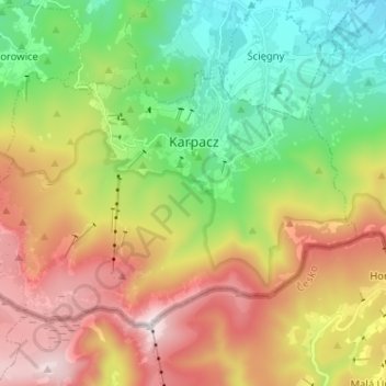
Cliquez sur la carte pour afficher l’altitude.
À propos de cette carte
Nom : Carte topographique Karpacz, altitude, relief.
Altitude moyenne : 933 m
Altitude minimum : 430 m
Altitude maximum : 1 596 m
The first settlements in the area of Karpacz are noted by the official website of the city as being of probable Celtic origin and date to the 4th or 3rd century BC when they inhabited the region as part of gold-digging taking place in the area. The area was part of medieval Poland, after the establishment of the state in the 10th century. In the early 12th century the area was generally uninhabited, as mentioned in the oldest Polish chronicle Gesta principum Polonorum. The first mention of permanent location within the current boundaries of the town is dated to the beginning of 15th century and connected to the destruction of a village called Broniów, whose inhabitants moved to settle the area currently located at the altitude of the town's railway station.
Autres cartes topographiques
Cliquez sur une carte pour visualiser sa topographie, son altitude et son relief.
Śnieżka / Sněžka
Poland > Lower Silesian Voivodeship > Karkonosze County > Karpacz
Śnieżka / Sněžka, Karpacz, Karkonosze County, Lower Silesian Voivodeship, 58-540, Poland
Altitude moyenne : 1 262 m