
Carte topographique Denpasar
Carte interactive
Cliquez sur la carte pour afficher l’altitude.
À propos de cette carte
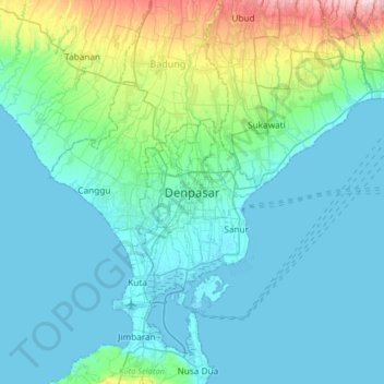
Nom : Carte topographique Denpasar, altitude, relief.
Altitude moyenne : 48 m
Altitude minimum : -1 m
Altitude maximum : 315 m
Denpasar is located at an elevation of 4 m (13 ft) above sea level. While the total area of 125.98 km2 or 2.18% of the total area of Bali Province. From the use of land, 2,768 hectares of land are paddy, 10,001 hectares are dry land, while the remaining land area is 9 hectares.