
Carte topographique Sonipat
Carte interactive
Cliquez sur la carte pour afficher l’altitude.
À propos de cette carte
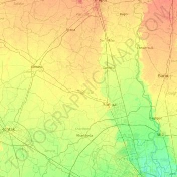
Nom : Carte topographique Sonipat, altitude, relief.
Lieu : Sonipat, Haryana, India (28.81490 76.46690 29.29471 77.23184)
Altitude moyenne : 225 m
Altitude minimum : 204 m
Altitude maximum : 250 m
Autres cartes topographiques
Cliquez sur une carte pour visualiser sa topographie, son altitude et son relief.
Para River
India > Haryana > Siwan > KACHI PISOL
Para River, KACHI PISOL, Siwan, Kaithal District, Haryana, 136033, India
Altitude moyenne : 235 m