
Carte topographique Rioja
Carte interactive
Cliquez sur la carte pour afficher l’altitude.
À propos de cette carte
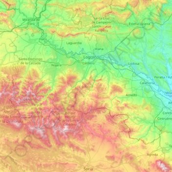
Nom : Carte topographique Rioja, altitude, relief.
Lieu : Rioja, Spain (41.91903 -3.13427 42.64426 -1.67870)
Altitude moyenne : 879 m
Altitude minimum : 270 m
Altitude maximum : 2 297 m
The mountains in La Rioja are part of the Iberian System. This mountain range extends to the south of the Ebro river, parallel to it at a distance of about 40 to 60 km (25 to 37 miles), with altitudes ranging between 1,000 and 2,000 m (3,300 and 6,600 feet). From the mountain range the Sierra de la Demanda runs northwards, into the heart of La Rioja, incorporating Monte San Lorenzo which, at 2,271 m (7,451 ft), is the highest peak in the province. Other mountains include Sierra de Camero Viejo, Sierra de Camero Nuevo, Sierra de Cebollera, and Picos de Urbión.