
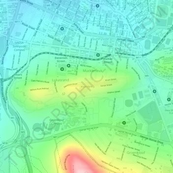
Carte topographique Kruin Park
Carte interactive
Cliquez sur la carte pour afficher l’altitude.
À propos de cette carte
Nom : Carte topographique Kruin Park, altitude, relief.
Altitude moyenne : 1 380 m
Altitude minimum : 1 322 m
Altitude maximum : 1 524 m
Autres cartes topographiques
Cliquez sur une carte pour visualiser sa topographie, son altitude et son relief.
Struben Dam
South Africa > Gauteng > City of Tshwane Metropolitan Municipality > Pretoria
Struben Dam, Lynnwood Glen, Tshwane Ward 46, Pretoria, City of Tshwane Metropolitan Municipality, Gauteng, South Africa
Altitude moyenne : 1 385 m
Trim Park
South Africa > Gauteng > City of Tshwane Metropolitan Municipality > Pretoria
Trim Park, Wonderboom South, Tshwane Ward 54, Pretoria, City of Tshwane Metropolitan Municipality, Gauteng, South Africa
Altitude moyenne : 1 270 m
Apies
South Africa > Gauteng > City of Tshwane Metropolitan Municipality > Pretoria
Apies, Pretoria, City of Tshwane Metropolitan Municipality, Gauteng, South Africa
Altitude moyenne : 1 250 m
Faerie Glen Nature Reserve
South Africa > Gauteng > City of Tshwane Metropolitan Municipality > Pretoria
Faerie Glen Nature Reserve, Tshwane Ward 46, Pretoria, City of Tshwane Metropolitan Municipality, Gauteng, South Africa
Altitude moyenne : 1 385 m
Freedom Park
South Africa > Gauteng > City of Tshwane Metropolitan Municipality > Pretoria
Freedom Park, Tshwane Ward 59, Pretoria, City of Tshwane Metropolitan Municipality, Gauteng, South Africa
Altitude moyenne : 1 390 m
Prince's Park
South Africa > Gauteng > City of Tshwane Metropolitan Municipality > Pretoria
Prince's Park, Salvokop, Tshwane Ward 60, Pretoria, City of Tshwane Metropolitan Municipality, Gauteng, South Africa
Altitude moyenne : 1 325 m