
Carte topographique Tysons
Carte interactive
Cliquez sur la carte pour afficher l’altitude.
À propos de cette carte
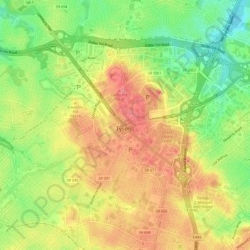
Nom : Carte topographique Tysons, altitude, relief.
Lieu : Tysons, Fairfax County, Virginia, United States of America (38.89855 -77.26526 38.93447 -77.19624)
Altitude moyenne : 121 m
Altitude minimum : 75 m
Altitude maximum : 164 m
Tysons is located at 38°55′7″N 77°13′47″W / 38.91861°N 77.22972°W / 38.91861; -77.22972 (38.918485, −77.229833) at an elevation of 486 feet (148 m). Located in Northern Virginia at the intersection of Virginia State Route 123 and State Route 7, Tysons is 11 miles (18 km) west of downtown Washington, D.C. and 6 miles (9.7 km) northeast of Fairfax, the county seat.