Géolocaliser

Carte topographique Morgan Hill

Cliquez sur la carte pour afficher l’altitude.

Morgan Hill

Morgan Hill is approximately 39 km (24 mi) south of downtown San Jose, 21 km (13 mi) north of Gilroy, and 24 km (15 mi) inland from the Pacific coast. Lying in a roughly 6 km-wide (4-mi-wide) southern extension of the Santa Clara Valley, it is bounded by the Santa Cruz Mountains to the west and the Diablo Range to the east. At the valley floor, Morgan Hill lies at an elevation of about 107 m (350 ft) above MSL.

À propos de cette carte
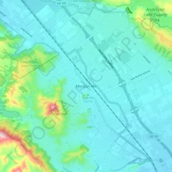
Nom : Carte topographique Morgan Hill, altitude, relief.

Lieu : Morgan Hill, Santa Clara County, California, 95037-3614, United States (37.09041 -121.69450 37.17041 -121.61450)

Altitude moyenne : 145 m

Altitude minimum : 87 m

Altitude maximum : 444 m

Équipez-vous pour votre prochaine aventure :

Montres GPS outdoor - Montres GPS pour randonnée, trail et trekking
📦Rangement matériel outdoor - Organisation de l'équipement
🔒Antivol de vélo haute sécurité - Protégez votre vélo lors de vos haltes en ville ou en parc
🍲Repas lyophilisés pour camping - Nourriture légère et nutritive pour les longues randonnées
🩹Kit de réparation de tente - Patchs adhésifs pour trous et déchirures sur le terrain

En tant que Partenaire Amazon, ce site perçoit une commission sur les achats éligibles sans surcoût pour vous.