
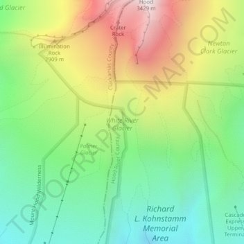
Carte topographique White River Glacier
Carte interactive
Cliquez sur la carte pour afficher l’altitude.
À propos de cette carte
Nom : Carte topographique White River Glacier, altitude, relief.
Altitude moyenne : 2 523 m
Altitude minimum : 1 980 m
Altitude maximum : 3 364 m
Autres cartes topographiques
Cliquez sur une carte pour visualiser sa topographie, son altitude et son relief.
Cascade Locks
USA > Oregon > Cascade Locks
Cascade Locks, Hood River County, Oregon, USA
Altitude moyenne : 101 m
Crook Glacier
Crook Glacier, Broken Top NW Ridge route, Deschutes County, Oregon, USA
Altitude moyenne : 2 347 m
Bend Glacier
Bend Glacier, Broken Top NW Ridge route, Deschutes County, Oregon, USA
Altitude moyenne : 2 350 m
Linn Glacier
Linn Glacier, Pacific Crest Trail, Deschutes County, Oregon, USA
Altitude moyenne : 2 359 m
Glisan Glacier
Glisan Glacier, McNeil Point Trail #600M, Hood River County, Oregon, USA
Altitude moyenne : 2 086 m
Ladd Glacier
Ladd Glacier, Barrett Spur, Hood River County, Oregon, USA
Altitude moyenne : 2 305 m
Jefferson Park Glacier
Jefferson Park Glacier, Pacific Crest Trail, Jefferson County, Oregon, USA
Altitude moyenne : 2 421 m
Palmer Glacier
Palmer Glacier, Mountaineer Trail #798, Clackamas County, Oregon, USA
Altitude moyenne : 2 424 m
Wallowa Mountains
Wallowa Mountains, Wallowa County, Oregon, USA
Altitude moyenne : 2 475 m
Newton Clark Glacier
Newton Clark Glacier, Cooper Spur Trail #600B, Hood River County, Oregon, USA
Altitude moyenne : 2 589 m
Eliot Glacier
Eliot Glacier, Eliot west moraine, Hood River County, Oregon, USA
Altitude moyenne : 2 316 m
Lathrop Glacier
Lathrop Glacier, Mt. Thielsen climber's trail, Douglas County, Oregon, USA
Altitude moyenne : 2 235 m
Lake Hilda
Lake Hilda, National Forest Development Road 4220, Marion County, Oregon, USA
Altitude moyenne : 1 689 m
Milk Creek Glacier
Milk Creek Glacier, Pacific Crest Trail, Jefferson County, Oregon, USA
Altitude moyenne : 2 508 m
Zigzag Glacier
Zigzag Glacier, Mountaineer Trail #798, Clackamas County, Oregon, USA
Altitude moyenne : 2 620 m
Prouty Glacier
Prouty Glacier, South Sister Climber Trail #36, Deschutes County, Oregon, USA
Altitude moyenne : 2 589 m
Diller Glacier
Diller Glacier, climber's trail, Deschutes County, Oregon, USA
Altitude moyenne : 2 416 m
Whitewater Glacier
Whitewater Glacier, Pacific Crest Trail, Jefferson County, Oregon, USA
Altitude moyenne : 2 460 m
Mount Tabor
Mount Tabor, Portland, Multnomah County, Oregon, 97215, USA
Altitude moyenne : 86 m
Carver Glacier
Carver Glacier, South Sister Climber Trail #36, Deschutes County, Oregon, USA
Altitude moyenne : 2 385 m
Kirkpatrick
USA > Oregon > Kirkpatrick
Kirkpatrick, Umatilla County, Oregon, USA
Altitude moyenne : 421 m
Coalman Glacier
Coalman Glacier, Cooper Spur Trail #600B, Hood River County, Oregon, USA
Altitude moyenne : 2 728 m
Clark Glacier
Clark Glacier, South Sister Climber Trail #36, Deschutes County, Oregon, USA
Altitude moyenne : 2 578 m
Thayer Glacier
Thayer Glacier, climber's trail, Deschutes County, Oregon, USA
Altitude moyenne : 2 423 m