
Carte topographique Hwado-myeon
Carte interactive
Cliquez sur la carte pour afficher l’altitude.
À propos de cette carte
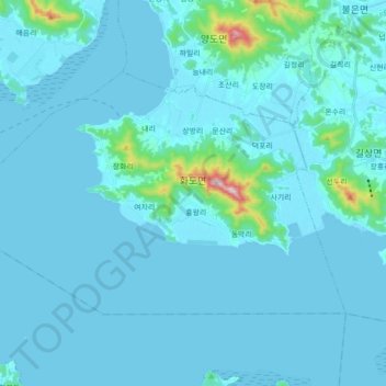
Nom : Carte topographique Hwado-myeon, altitude, relief.
Lieu : Hwado-myeon, Ganghwa-gun, Incheon, South Korea (37.56800 126.31292 37.65557 126.48848)
Altitude moyenne : 28 m
Altitude minimum : -3 m
Altitude maximum : 448 m
Autres cartes topographiques
Cliquez sur une carte pour visualiser sa topographie, son altitude et son relief.
Turczaninow Hornbeam Tree at Chamseongdan Altar
South Korea > Ganghwa-gun > Incheon > Hwado-myeon
Turczaninow Hornbeam Tree at Chamseongdan Altar, 당근로, Hwado-myeon, Ganghwa-gun, Incheon, 23060, South Korea
Altitude moyenne : 155 m